Bolivia
|
High-elevation peatlands in the Andes
Cordillera Real High-elevation peatlands in the Andes, locally known as bofedales, are semi-aquatic ecosystems characterized by cushion plants and humid soil. They are important habitats for species of flora and fauna that provide vital ecological services to society such as carbon absorption, organic matter decomposition, nutrient filtering and water regulation. In the shallow pools of bofedales inhabit a particular diversity of aquatic species that play a central role in the functioning of these ecosystems such as the organic matter decomposition. I studied the effect of key variables on aquatic diversity: glacier influence, area and environmental heterogeneity of bofedales. Knowledge on these interrelationships is essential for conservation measures. See more in Publications. Photo credits: E. Quenta and O. Dangles. |
|
|
Geothermal streams and bofedales in the Andes. Sajama National Park
In Sajama National Park, geothermal streams are interesting systems to understand the ecology of aquatic diversity because it is possible to analyze the aquatic diversity, structure and functioning within a broad range of temperatures (15-36ºC) in a relatively small spatial scale (6km) and considering their natural environment. Here, I am working as a research associate at the project “ Aquatic biota reponses to temperature in a high Andean geothermal stream” with the IRD institution Photo credit: E. Quenta and O.Dangles |
|
The laboratory analysis:
After collecting water samples in the field, I have worked arduously in the lab analyzing water samples from Bofedales and geothermal streams for two years. Yes, there were side effects (my eyes are not the same as before the analysis), but I have worked hard and with all of my passion to continue my scientific career. If you would like to know more about my past laboratory experience and other personal details you might be interested in read this interview
After collecting water samples in the field, I have worked arduously in the lab analyzing water samples from Bofedales and geothermal streams for two years. Yes, there were side effects (my eyes are not the same as before the analysis), but I have worked hard and with all of my passion to continue my scientific career. If you would like to know more about my past laboratory experience and other personal details you might be interested in read this interview
Ecuador
|
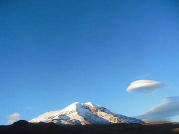
Chimborazo, Antisana and Carihuairazo Valcanos
Glacier streams I worked as a research assistant in the project “Glacier streams in the Ecuadorian Andes”. I had the opportunity to visit Antisana, Chimborazo, and Carihuairazo mountains. Specially, Carihuairazo is predicted to disappear in the next decade and the project aimed to understand how terrestrial and aquatic species colonize the new sites opened by the glacier retreat. Photo credit: E. Quenta. |
|
Tropical Andes
|
Chile, Argentina, Bolivia, Perú, Ecuador, Colombia and Venezuela.
As part of the training and mentoring program regarding the process of the Intergovernmental Panel on Climate Change (IPCC) organized by Swiss institutions such as the Moutain Research Initiative and the University of Zurich, and funded by the Swiss Development Cooperation, I worked in a review paper in order to provide a benchmark of freshwater conservation in the tropical Andes, motivated mainly on the conservation of streams, rivers, lakes, glacierized lakes and catchments of high-elevation. As a part of the training I also served as Expert Reviwer of the Working Group II Contribution to the IPCC Sixth Assessment Report. Photo credit: E. Quenta. |
|
Other mountain regions
Andes, European Alps, Rocky Mountains, Carpathian Mountains, and others.
As a part of my consultancy activities in the United Nations Environment Programme (UNEP), I have supported the office’s activities to contribute to the UN Decade on Ecosystem Restoration 2021–2030 by identifying and analyzing the specificities of mountainous settings that are important when developing and implementing restoration activities in mountain ecosystems.
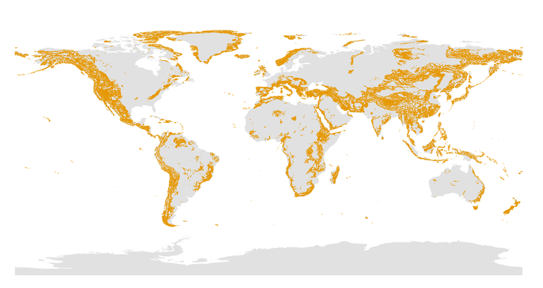
Worlwide Mountain Distribution. E. Quenta elaborated the map from the GMBA Mountain Inventory V2. A hirarchical of the world's mountain for global comparative science.
